Parking Lot Map Boundary Methodology
Zoning boundaries for various cities were often irregular, lacked a definitive form, transcended physical boundaries, and had opposing zones located within each other. To solve this, the following method was developed to create boundaries that most accurately reflected the zoning boundary and the most valuable land in the city.
Districts Chosen:
The zoning district(s) that allow for the densest development throughout the city were mapped. This was often the Downtown or Central Business District boundary, which accounted for about two-thirds of the total boundaries created. Please see the bottom of this page to view all districts chosen for a particular city.
Use of Physical Boundaries:
Many cities have dense zoning districts that transcend physical boundaries, such as interstate highways, rivers, and railroads. Areas that are separated from the downtown have drastically different parking land use than that of the Central Business District area. Many times this is an industrial area that is rezoned to be redeveloped or a single-family residential area with the same intention. To prevent these areas from being measured all areas outside of hostile boundaries that disrupt the central business district were excluded from the map boundary. Twenty-one cities had interstate highways, three had rivers, and three had interstate highways and rivers as part of their boundaries. This method hopes to make all cities comparable by mapping their most valuable, centrally located, and easily developed areas in the city.
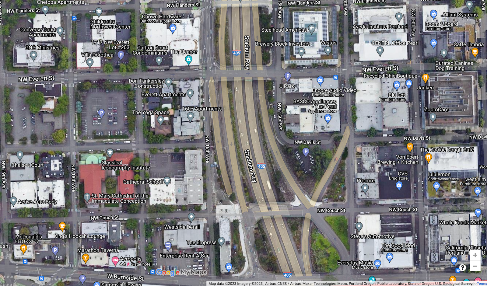
Fig 1. Depicts the difference in demand for land on the east and west sides of Interstate 405. West of the Central Business District has five times as much parking.
Creating a Standard Form for Boundaries:
All zoning districts mapped must be contiguous. The main part of the district must physically border a block on one side of the same zone to be mapped. Zones that were catycorner to a like zone were excluded and also zones that were not connected physically were excluded. All zones that were fully surrounded by the main zone were also included.
Fig 2. Depicts a catycorner zone that was excluded from the boundary.
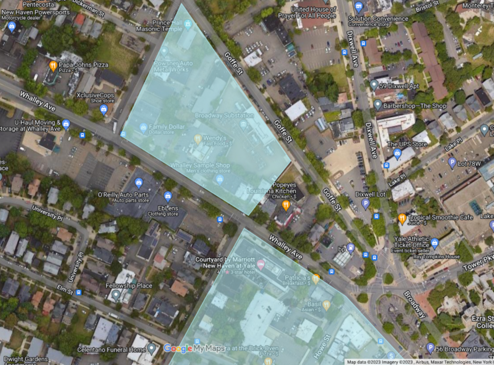
Fig 3. Depicts three IL zones that were included in the boundary and one CD zone that was excluded.

List of Zoning Districts for Each City:
| City | Link | Zoning Districts |
| Albany | Zoning | Mixed-Use Downtown (MU-DT) |
| Albuquerque | Zoning | Central Business District |
| Allentown | Zoning | Central Business District (B-2) and Institutional and Governmental (IG) |
| Anaheim | Zoning | General Commercial (G-C) south of W Sycamore St and east of N Citron St |
| Anchorage | Zoning | Central Busines, Core (B-2A), Central Business, Intermediate (B-2B), Central Business, Periphery (B-2C) |
| Arlington | Zoning | Downtown Business (DB) |
| Atlanta | Zoning | Downtown Special Public Interest District (SP-1) in subarea 1, 5, 6, and 7 west of Interstate 85 |
| Aurora | Zoning | Original Aurora Main Street (OA-MS) south of E 16th Ave and North of E 14th Ave |
| Austin | Zoning | Central Business District (CBD) |
| Bakersfield | Zoning | Central Business and Civic Center |
| Baltimore | Zoning | All C-5 Zoning Districts west of Interstate 83 and North of Interstate 395 |
| Baton Rouge | Zoning | Business (C5) |
| Birmingham | Zoning | Central Business District (B-4) |
| Boston | Zoning | Boston has a vast network of business districts, this boundary represents districts that have a majority of their area zoned for a FAR above 6. Those districts include North Station Economic Development Area, Bulfinch Triangle, Government Center/Markets, Central Artery Special, Midtown Central, Leather District, South Station Economic Development Area, Chinatown, Bay Village Neighborhood, Boston Proper (FAR of 6 and above), Stuart Street, and Huntington Avenue/Prudential Center |
| Buffalo | Zoning | Downtown Hub (N-1D) and Mixed-Use Core (N-1C) north of Interstate 190 |
| Charleston | Zoning | General Business (GB), Mixed Use (MU-1 and MU-2), Mixed Use Workforce Housing (MU-1/WH and MU-2/WH) south of Interstate 26 |
| Charlotte | Zoning | Uptown Mixed-Use District within Interstate 277 Loop |
| Chicago | Zoning | Chicago’s Downtown Core District (DC-16) lacks a definitive form, this boundary represents a majority of the DC-16 zoning boundary. |
| Cincinnati | Zoning | Downtown District (DD) north of Interstate 71 |
| Cleveland | Zoning | All Limited Retail Business and General Retail Business east of the Cuyahoga River and west of Interstate 90 |
| Colorado Springs | Zoning | Form-Based Zone (FBZ) |
| Columbia | Zoning | Downtown Activity Center/Cooridor (DAC) |
| Columbus | Zoning | Downtown District (DD) inside Interstate 70, 71 and 670. |
| Corpus Christi | Zoning | Central Business District |
| Dallas | Zoning | Central Area (CA-1(A)) |
| Dayton | Zoning | Central Business District (CBD) |
| Denver | Zoning | Downtown Core (D-C), Downtown Theater District (D-TD), and Lower Downtown (D-LD) |
| Des Moines | Zoning | Downtown (DX1) |
| Detroit | Zoning | B4 General Business District (B4), Major Business District (B5), General Services District (B6), Special Development District Casinos (SD5), Public Center Adjacent District (Restricted Central Business District) (PCA), and Planned Development District (PD) within the Interstate 75, 375, and US Highway 10 Loop |
| El Paso | Zoning | All Central Business District (C-5) |
| Fort Myers | Zoning | Planned Unit Development By Ordinance Urban & Civic (PUD), Urban Center (U-CTR), Urban Core (U-CORE), Civic (CIVIC) |
| Fort Worth | Zoning | Central Business (H) west of Amtrack Railroad |
| Fresno | Zoning | Downtown Core (DTC) and Downtown General (DTG) |
| Grand Rapids | Zoning | City Center (CC) south of Interstate 196, east of Grand River, and north of Route 131 |
| Greensboro | Zoning | Central Business (CB) |
| Harrisburg | Zoning | Downtown Center (DC) south of the Amtrak Tracks |
| Hartford | Zoning | All Downtown (DT) |
| Henderson | Zoning | Downtown Mixed-Use (DX) and Downtown Public (DP) |
| Honolulu | Zoning | Central Business Mixed Use (BMX-4) |
| Houston | Google Maps | The City of Houston does not have zoning, but development is governed by ordinance codes that address how property can be subdivided. The City codes do not address land use. We used Google Maps to locate the downtown boundary of Houston east of Interstate 69 and south of Buffalo Bayou |
| Indianapolis | Zoning | All Central Business District north of Amtrack’s Cardinal Line |
| Jacksonville | Zoning | Commercial Central Business District (CCBD) west of Hogans Creek, east of McCoy Creek, and north of the St. Johns River |
| Jersey City | Zoning | Redevelopment Districts: Newport, Harsimus Cove Station, Powerhouse Arts District, Exchange Place North, Block 13102, Paulus Hook, 1 Exchange Place, and Colgate |
| Kansas City | Zoning | Future Land Use – Downtown Core and Downtown Residential |
| Knoxville | Zoning | Downtown Knoxville Warehouse Subdistrict (DK-W), Downtown Knoxville Historic Core Subdistrict (DK-H), Downtown Knoxville Grid Subdistrict (DK-G), and Downtown Knoxville Boulevards Subdistrict (DK-B) east of Interstate 275 and west of Route 158 |
| Las Vegas | Zoning | General Commercial (C-2) and (T5 Main Street (T5-MS) between Interstate 515 and E Charleston Boulevard |
| Lexington | Zoning | Center Business (B-2B) and Downtown Business (B-2) |
| Lincoln | Zoning | Central Business District (B-4) |
| Little Rock | Zoning | Urban Use (UU) and Planned Commercial District (PCD) within Interstate 630 and 30 |
| Long Beach | Zoning | Planned Development 30 (PD-30) and Planned Development 6 (PD-6) |
| Los Angeles | Zoning | All Commercial and Multiple Family Residential in the Downtown Community Plan Area |
| Louisville | Zoning | Downtown Commercial (C-3) |
| Madison | Zoning | Downtown Core District (DC), Urban-Mixed Use (UMX), and Planned Development (PD) |
| McAllen | Zoning | General Commercial Business (C-3) within the Central Business District boundaries |
| Melbourne | Zoning | Central Business District (C-3) north of Crane Creek. |
| Memphis | Zoning | All Central Business District (CBD) west of Route 51. |
| Mesa | Zoning | Downtown Core (DC) |
| Miami | Zoning | All Urban Core Zones T6-36 and above |
| Milwaukee | Zoning | Downtown Civic Activity (C9D), Downtown Major Retail (C9F), Downtown Office and Service (C9E), Downtown Mixed Activity (C9G) |
| Minneapolis | Zoning | Core 50 Built Form Overlay District (BFC50) |
| Nashville | Zoning | Downtown Commercial (DTC) |
| New Orleans | Zoning | All Central Business District (CBD) |
| New York City | Zoning | New York City lacks natural boundaries and has a vast network of business districts this boundary represents a majority of the C-5 and C-6 Commercial Districts in Midtown Manhattan |
| Newark | Zoning | Living Downtown Plan (RDV-SD-6) and Downtown Core District Redevelopment Plan (RDV-SD-9) located on page 18 |
| New Haven | Zoning | All Business Districts (BD) |
| Norfolk | Zoning | All Downtown (D) districts south of route 58 and west of Interstate 264 |
| Oakland | Zoning | All Central Business Districts (CBD) |
| Oklahoma City | Zoning | Downtown Business District (DBD) north of Interstate 40 |
| Omaha | Zoning | Central Business District (CBD) within Interstate 480 |
| Orlando | Zoning | Downtown Metropolitan Activity Center (AC-3A) east of Interstate 4 |
| Philadelphia | Zoning | Commercial Mixed-Use (CMX-5) east of the Schuylkill River |
| Phoenix | Zoning | Downtown Business Core (DTC) |
| Pittsburgh | Zoning | All Golden Triangle Districts (GT) west of Interstate 579 |
| Portland | Zoning | Central Commercial (CX) east of Interstate 405 and west of the Willamette River |
| Providence | Zoning | All Downtown Districts (D-1) |
| Raleigh | Zoning | Downtown Mixed-Use (DX) |
| Richmond | Zoning | Central Business District (B-4 and B-5) |
| Riverside | Zoning | Downtown Specific Plans: Justice Center District (DSP-JC), Almond Street District (DSP-AS), Raincross District (DSP-RC), Neighborhood Commercial (DSP-NC) |
| Rochester | Zoning | All City Center and Urban Renewal Districts within the Inner Loop. |
| Sacramento | Zoning | Central Business District (C-3) south of the Union Pacific Railroad and east of Interstate 5 |
| Saint Paul | Zoning | Central Business (B-4) and Central Business Service (B-5) south of Interstate 94 |
| Salt Lake City | Zoning | Central Business District (D-1), Downtown Support District (D-2), Downtown Warehouse/Residential District (D-3), and Secondary Central Business District (D-4). |
| San Antonio | Zoning | Downtown (D) |
| San Bernardino | Zoning | Commercial Regional – Malls (CR-1), Commercial Regional – Downtown (CR-2), and Commercial Office (CO). |
| San Diego | Zoning | The following City Center Planned Districts: Employment/Residential Mixed-Use (ER), Residential Emphasis (RE), Mixed Commercial (MC), Core (C), Ballpark Mixed-Use (BP), Gaslamp Quarter Planned District Ordinance (GQPD), and Marina Planned District (MPD-MARINA). |
| San Francisco | Zoning | Downtown Office (C-3-O) |
| San Jose | Zoning | Downtown Commercial (DC) east of Route 87 |
| San Juan | Zoning | All Commercial (C-3) zoning districts in Hato Rey. Located in page 6D AND 5D |
| Santa Ana | Zoning | Specific Development 84 (SD-84) excluding manufacturing subdistricts and east of the railroad. |
| Sarasota | Zoning | Downtown Core (DTC) and Downtown Bayfront (DTB) |
| Seattle | Zoning | Downtown west of Interstate 5 |
| St. Louis | Zoning | Central Business District west of Interstate 44 and north of Interstate 64 |
| St. Petersburg | Zoning | All Downtown Center Districts |
| Stockton | Zoning | Downtown Commercial (DC) north of Route 4 |
| Tampa | Zoning | Central Business District (CBD) north of Selmon Expressway |
| Toledo | Zoning | Downtown Commercial (CD) |
| Tucson | Zoning | Office/Commercial/Residential Zone (OCR-2) |
| Tulsa | Zoning | Central Business District |
| Virginia Beach | Zoning | Oceanfront Resort District (OR) |
| Washington DC | Zoning | Downtown Zones: D-1-R, D-2, D-3, D-4, D-4-R, D-5, D-5-R, D-6, D-6-R, and D-7 |
| Wichita | Zoning | Central Business District |
| Worcester | Zoning | BG-6 |